In the last post we looked at the many difficult paths that can take us to the summit of cartographic nirvana known as the "Buffalo Tint", as rocked by National Geographic Maps and others
As I noted, this effect has traditionally been impossible to pull off in a GIS platform like ArcMap or QGIS. Tilemill initially got us a little bit closer by giving us full control over styling possibilities with CartoCSS code.
But now, as of Tilemill 0.10.0, compositing functions make this kind of effect a snap. Let's look at making a full Buffalo Fade, still using South Sudan as an example. Specifically, we're going to make a fade mask in Tilemill that can be laid over some Mapbox base layers in a web map.


[Alternately, in this case you can do it by just compositing every country that isn't South Sudan and eliminate the buffer processing above. Here's the CartoCSS to do that]
That's it. Export to MBTiles format and drop it on top of a base map of your choice. You're off to the races:

There are still a few bugs when using this for dynamic tiles, notably some tile-edge artifacts that break up the smoothness. But overall I'm looking forward to messing around with these new compositing capabilities
As I noted, this effect has traditionally been impossible to pull off in a GIS platform like ArcMap or QGIS. Tilemill initially got us a little bit closer by giving us full control over styling possibilities with CartoCSS code.
But now, as of Tilemill 0.10.0, compositing functions make this kind of effect a snap. Let's look at making a full Buffalo Fade, still using South Sudan as an example. Specifically, we're going to make a fade mask in Tilemill that can be laid over some Mapbox base layers in a web map.
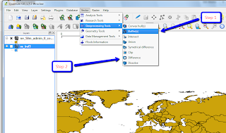
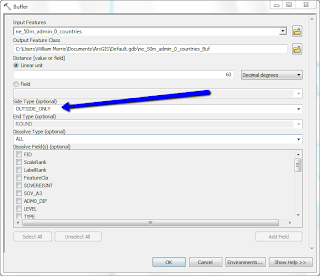
Step 1: Preprocessing a Mask
This step - preprocessing in a GIS platform - is optional, it just depends on where you want the fade to begin. The purpose of preprocessing is to create a fixed feature mask;- QGIS: Run a buffer on your focal feature, larger than the convex hull of the feature for good measure. Then run a difference process between the buffer and the focal feature.

- ArcGIS: Run a buffer on the focal feature, with "Side Type" set to OUTSIDE-ONLY, again to a good distance out beyond your feature's bounding box.

Either way you're aiming for a feature mask that looks like this:

Step 2: Into Tilemill

[Alternately, in this case you can do it by just compositing every country that isn't South Sudan and eliminate the buffer processing above. Here's the CartoCSS to do that]
That's it. Export to MBTiles format and drop it on top of a base map of your choice. You're off to the races:

There are still a few bugs when using this for dynamic tiles, notably some tile-edge artifacts that break up the smoothness. But overall I'm looking forward to messing around with these new compositing capabilities
I'm trying this techniques out - getting partial success.
ReplyDeleteWhen I use a donut polygon, my geography in the middle gets faded out in the center.
If I use the donut hole polygon and apply the CSS, I get a similar effect to your example.
Is there a way to use this technique on a raster layer without applying it to the rest of the underlying layers? The only way I can think of to do it is to do separate exports and stack them up at mapping time.
Thanks for the example, this has been a huge help.