I just (days later than everyone else) came across this awesome Google Maps application built by Darren Wiens using the buckled-on graphics capabilities of paper.js. It strikes me as a perfect example of good imagination at work on complex geographic problems. Specifically, this is a mixture of pure javascript, HTML5 browser-boosting and advanced trip routing, all to make a cool visualization of where traffic bottlenecks will arise.
The application calls on paper.js to generate an endless series of random point-to-point trips within the map view, then passes them to Google's routing API and renders the result visually as a trip on the local road network. Over a short time, the traces of the trips build up into a density map of highest traffic:
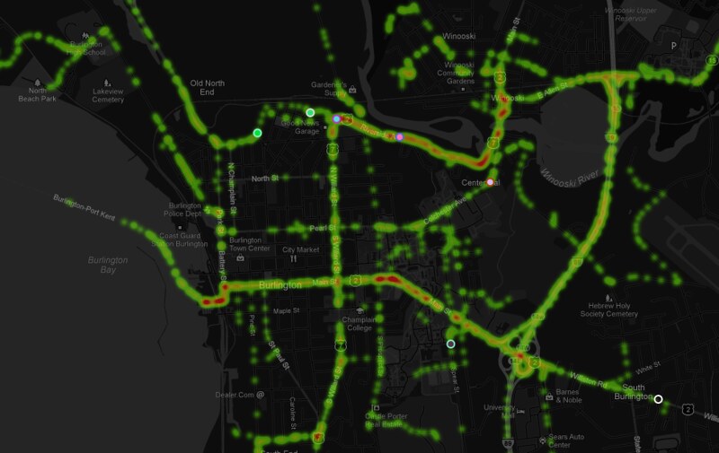
So as is my wont, I grabbed the code (Thanks again to Mr. Wiens) and adapted it to my home territory of Burlington, VT, with a bit of map styling for contrast (modern browser required):
The application calls on paper.js to generate an endless series of random point-to-point trips within the map view, then passes them to Google's routing API and renders the result visually as a trip on the local road network. Over a short time, the traces of the trips build up into a density map of highest traffic:
So as is my wont, I grabbed the code (Thanks again to Mr. Wiens) and adapted it to my home territory of Burlington, VT, with a bit of map styling for contrast (modern browser required):
I intend to spend a lot more time figuring out the ways that new graphics modules can interact with the maps I build, but as always I'm limited by my own imagination. It seems like the technology is increasingly unlimited in capability.
No comments:
Post a Comment